CITY OF GRAND JUNCTION
Ordinance No. 3571
AN ORDINANCE VACATING A PORTION OF THE 24 3/4 ROAD RIGHT-OF-WAY LOCATED BETWEEN RIVER ROAD AND THE BLUE HERON TRAIL
RECITALS:
A vacation of a portion of the dedicated right-of-way for 24 3/4 Road has been requested by the adjoining property owners.
The City Council finds that the request is consistent with the Growth Plan, the Grand Valley Circulation Plan and Section 2.11 of the Zoning and Development Code.
The Planning Commission, having heard and considered the request, found the criteria of the Code to have been met, and recommends that the vacation be approved.
NOW, THEREFORE BE IT ORDAINED BY THE CITY COUNCIL OF THE CITY OF GRAND JUNCTION THAT:
The following described dedicated right-of-way for 24 3/4 Road is hereby vacated subject to the listed conditions:
1. Applicants shall pay all recording/documentary fees for the Vacation
Ordinance, any easement documents and dedication documents.
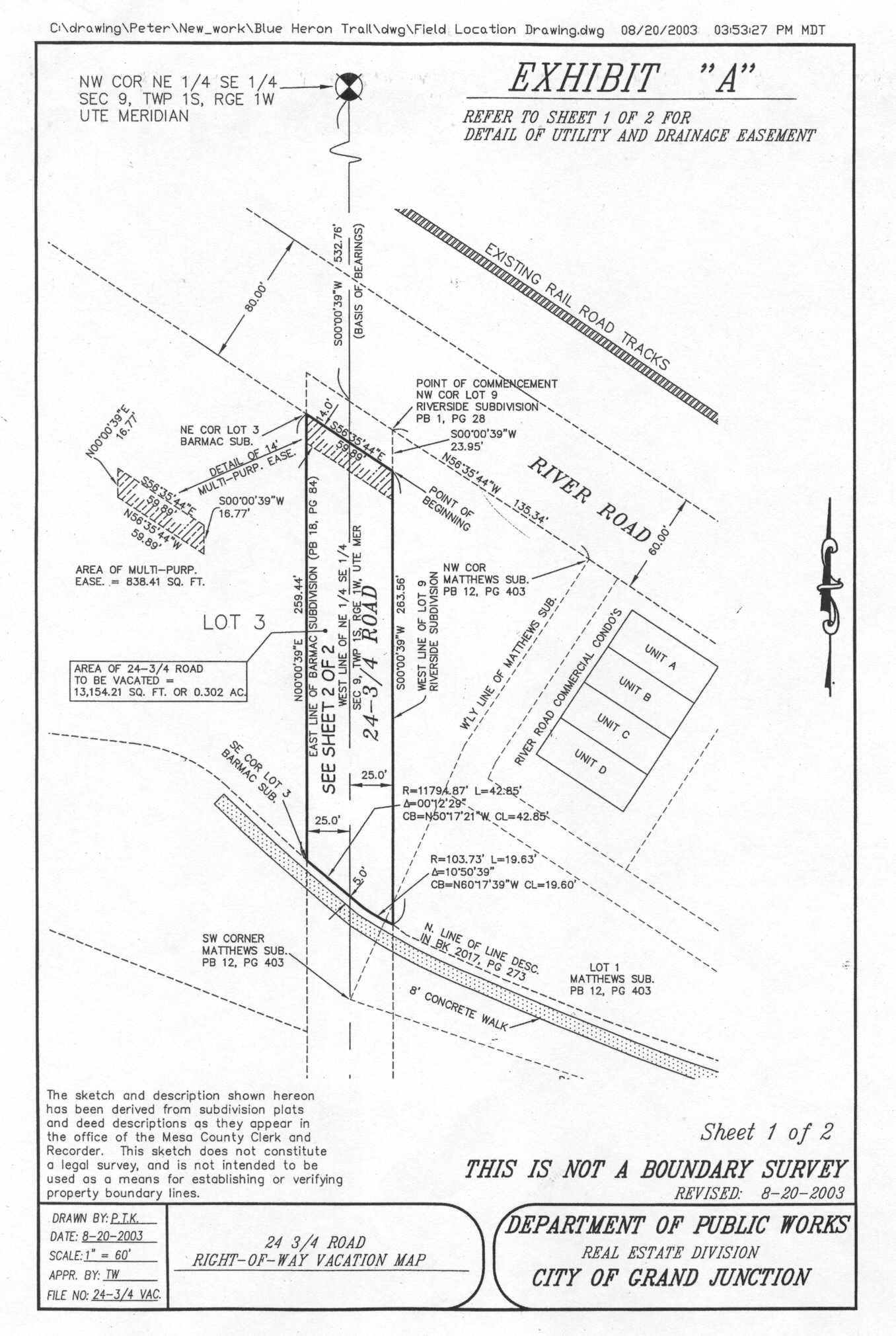
The following right-of-way is shown on “Exhibit A” (Sheet 1 & 2) as part of this vacation of description.
Dedicated right-of-way to be vacated:
A portion of the following described public right-of-way for 24 3/4 Road, situate in the Southeast 1/4 of Section 9, Township 1 South, Range 1 West of the Ute Meridian, County of Mesa, State of Colorado, as dedicated with the plat of Riverside Subdivision, recorded in Plat Book 1 at Page 28 in the office of the Mesa County Clerk and Recorder, said right-of-way being more particularly described as follows, to wit:
Commencing at the Northwest Corner of Lot 9 of said Riverside Subdivision, and considering the West line of said Lot 9 to bear S 00°00’39” W with all bearings contained herein being relative thereto; thence along a line which is common with the West boundary line of said Lot 9 and the East right-of-way line for 24 3/4 Road, S 00°00’39” W a distance of 23.95 feet to the True Point of Beginning;
Thence along said common line, S 00°00’39” W a distance of 263.56 feet to Northerly, whose long chord bears N 60°17’39” W with a long chord length of 19.60 feet; thence leaving said common line, Westerly along the arc of said curve, through a central angle of 10°50’39”, a distance of 19.63 feet to a point of compound curvature of a 11,794.87 foot radius non-tangent curve, concave Northeasterly, whose long chord bears N 50°17’22” W with a long chord length of 42.85 feet; thence Northwesterly along the arc of said curve, through a central angle of 00°12’29”, a distance of 42.85 feet to a point being the Southeast corner of Lot 3 of Barmac Subdivision as recorded in Plat Book 18 at Page 84 in the office of the Mesa County Clerk and Recorder;
Thence along a line which is common with the East boundary of said Lot 3 and the West right-of-way line for B 3/4 Road, N 00°00’39” E a distance of 259.44 feet to the Northeast corner of Lot 3 of said Barmac Subdivision;
Thence leaving said common line, S 56°35’44” E a distance of 59.89 feet to the Point of Beginning,
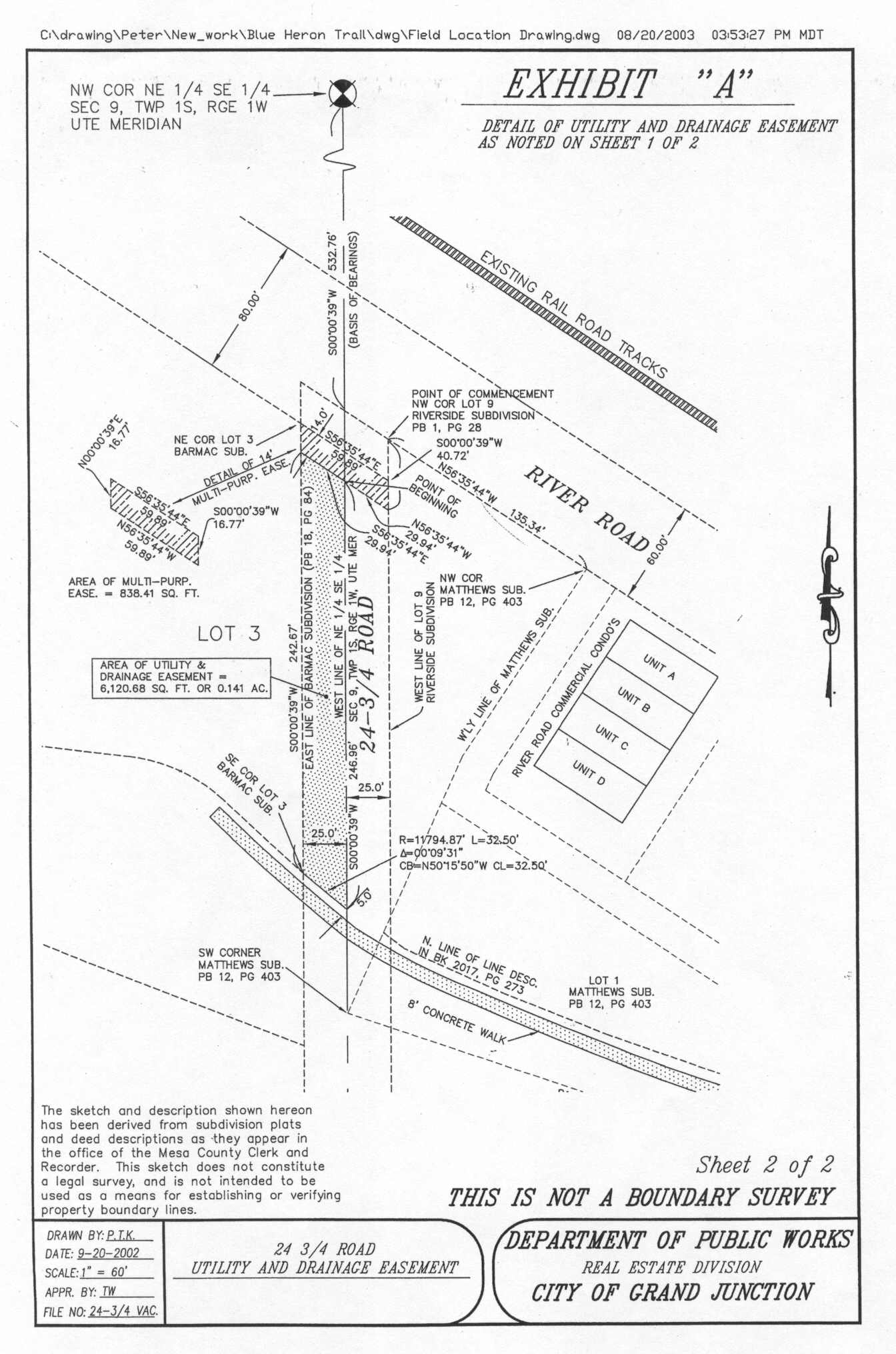
EXCEPTING THEREFROM the reservation by the City of a 14-foot wide Multi-Purpose Easement for the use and benefit of the City and for the use and benefit of the Public Utilities, as approved by the City, as Perpetual Easements for the installation, operation, maintenance, repair and replacement of utilities and appurtenances related thereto, as approved by the City, including, but not limited to, electric lines, cable television lines, natural gas pipelines, sanitary sewer lines, storm sewers and storm water drainage facilities, water lines, telephone lines, and also of the installation, operation, maintenance, repair and replacement of traffic control facilities, street lighting, landscaping, trees and grade structures, as approved by the City, on, along, over under, through and across the following described portion of the aforedescribed right-of-way, to wit:
Commencing at the Northwest Corner of Lot 9 of said Riverside Subdivision; thence along a line which is common with the West boundary line of said Lot 9 and the East right-of-way line for 24 3/4 Road, S 00°00’39” W a distance of 23.95 feet to the True Point of Beginning;
Thence S 00°00’39” W along the West boundary of said Lot 9 a distance of 16.77 feet;
Thence leaving the West boundary line of said Lot 9, N 56°35’44” W a distance of 59.89 feet to a point on the West boundary line of Lot 3 of Barmac Subdivision as recorded in Plat Book 18 at Page 84 in the office of the Mesa County Clerk and Recorder;
Thence N 00°00’39” E along the West boundary line of said Lot 3 a distance of 16.77 feet to the Northeast Corner of said Lot 3;
Thence leaving the East boundary line of said Lot 3, S 56°35’44” E a distance of 59.89 feet to the Point of Beginning.
-AND-
EXCEPTING THEREFROM the reservation by the City of a 25-foot wide Utility and Drainage Easement for the use and benefit of the City and for the use and benefit of the Public Utilities, as approved by the City, as a Perpetual Easement for the installation, operation, maintenance, repair and replacement of utilities and appurtenances related thereto, and for the installation, operation, maintenance, repair and replacement of storm sewers and storm water drainage facilities and appurtenances related thereto, on, along, over under, through and across the following described portion of the aforedescribed right-of-way, to wit:
Commencing at the Northwest Corner of Lot 9 of said Riverside Subdivision, and considering the West line of said Lot 9 to bear S 00°00’39” W with all bearings contained herein being relative thereto; thence along a line which is common with the West boundary line of said Lot 9 and the East right-of-way line for 24 3/4 Road, S 00°00’39” W a distance of 40.72 feet; thence leaving said common line, N 56°35’44” W a distance of 29.94 feet to a point on the West line of the Northeast Quarter of the Southeast Quarter (NE 1/4 SE 1/4) of said Section 9 and being the True Point of Beginning; thence S 00°00’39” W along the West line of the NE 1/4 SE 1/4 of said Section 9, a distance of 246.96 feet to a point being the beginning of a 11,794.87 foot radius non-tangent curve, concave Northeasterly, whose long chord bears N 50°15’50” W with a long chord length of 32.50 feet; thence Northwesterly along the arc of said curve, through a central angle of 00°09’31”, a distance of 32.50 feet to a point being the Southeast corner of Lot 3 of Barmac Subdivision as recorded in Plat Book 18 at Page 84 in the Office of the Mesa County Clerk and Recorder;
Thence along a line which is common with the East boundary of said Lot 3 and the West right-of-way line for B 3/4 Road, N 00°00’39” E a distance of 242.67 feet;
Thence leaving said common line, S 56°35’44” E a distance of 29.94 feet to the Point of Beginning.
Said easements shall include the right of ingress and egress for workers and equipment to survey, maintain, operate, repair, replace, control and use said Easements, and to remove objects interfering therewith, including the trimming of trees and bushes as may be required to permit the operation of standard utility construction and repair machinery. Further, said Easements shall not be burdened or overburdened by the installation, construction or placement of any structures or any other item or fixture which might be detrimental to the facilities of the City and/or the Public Utilities or which might act to prevent reasonable ingress and egress for workers and equipment on, along, over, under, through and across the Easement areas.
Said parcel containing an area of 0.302 Acres more or less, as described.
Introduced for first reading on this 3rd day of September, 2003
PASSED and ADOPTED this 17th day of September, 2003.
ATTEST:
/s/ Harry Butler
President of City Council Pro Tem
/s/ Stephanie Tuin
City Clerk