ORDINANCE NO. 3623
AN ORDINANCE AMENDING THE CITY OF GRAND JUNCTION’S “SUBMITTAL STANDARDS FOR IMPROVEMENTS AND DEVELOPMENT”, SSID MANUAL, AND AUTHORIZING PUBLICATION OF THE AMENDMENTS BY PAMPHLET
Recitals:
Ordinance No. 3390 adopted the City of Grand Junction Zoning and Development Code, including Submittal Standards for Improvements and Development (SSID).
Since the adoption of the Zoning and Development Code certain corrections, deletions and amendments to the SSID Manual have been proposed. Many of the amendments proposed for adoption are corrections and additions necessitated by working with and through the “new” Zoning and Development Code.
The revised SSID manual is available for review in the Community Development Department and the City Clerk’s office. Because of the number of pages constituting the amendments the Council has determined that publication in book or pamphlet, as authorized by the Charter, is appropriate.
NOW THEREFORE BE IT ORDAINED BY THE CITY COUNCIL OF THE CITY OF GRAND JUNCTION THAT:
1. The SSID Submittal Standards for Improvements and Developments is hereby amended to read as shown in the attached book or pamphlet. Specific references to each section number of each amendment, as well as the specific changes to the text are shown therein.
2. On January 13, 2004, the Planning Commission considered the amendments to the SSID manual and recommended approval to the City Council of the text amendments to the SSID Manual
2. All amendments are necessary or required by law and the amendments are in accordance with law.
3. Because of the number of pages, (approximately 150) publication by book or pamphlet is authorized in accordance with the Charter Article VI, Paragraph 51.
4. The hearing prior to final passage shall be held on April 21, 2004 at 7:30 p.m. in the Council chambers located at 250 N. 5th Street Grand Junction Colorado. The purpose of such hearing being the consideration of the amendments to the SSID Manual, as stated in this ordinance.
5. The book or pamphlet containing the amendments shall be available for inspection in the City Community Development Department and the City Clerk’s Office, 250 N.5th Street, Grand Junction CO. Hours for inspections shall be 8:00 a.m. to 5:00 p.m., Monday through Friday except legal holidays.
6. All ordinances or parts of ordinances inconsistent with the provisions of this ordinance are hereby repealed.
INTRODUCED ON FIRST READING this 17th day of March, 2004.
PASSED, ADOPTED AND APPROVED this 21st day of April, 2004.
Attest:
/s/: Harry Butler
President of the Council Pro Tem
/s/: Stephanie Tuin
City Clerk
I. PURPOSE AND SCOPE
A. PURPOSE
1. Development codes and related design and improvement standards encourage consistency of quality planning, design and construction. By thorough application of development regulations, owners and the public at large will experience less adverse affects from development practices, and when high quality development is achieved, they will enjoy a better quality of life.
2. The SSID regulations present in clear, concise terms what is required for various development to occur; the content of the applications, the requirements for various plans, reports and other details are stated.
3. The SSID regulations have the force and effect of law but the Director has the authority to vary the standards when appropriate and the general intent of the requirement is still met.
B. AUTHORITY AND SCOPE
1. Ordinance. Ordinance Number 3623, adopted by the Grand Junction City Council at a regular public hearing meeting held April 21, 2004 authorizes these regulations.
2. Jurisdiction. These regulations apply to all development which occurs within the City of Grand Junction, to all proposed infrastructure and improvements which will become the property of the City and also to systems which the City manages and/or maintains.
3. Enforcement Responsibility. The Community Development and Public Works Departments are responsible for enforcing these regulations. The assigned project planner from the Community Development Department is the liaison with the developer through the design/application phase. Either the assigned project planner or the assigned City Development Engineer is the liaison during the construction phase.
4. Conflicting Provision. If these regulations conflict with other City ordinances, policies, regulations and/or implementing manuals or documents, then the ordinance, regulation, policy and/or implementing manual(s) that is established or adopted later in time and/results in a better result for the City shall control.
II. USE AND DEFINITIONS
A. SSID MANUAL USE AND FORMAT
1. Manual Format. This manual is comprised of three categories or parts. Understanding the parts will help when using the manual. The categories are briefly described below.
PART ONE: GENERAL PROVISIONS
Part One consists of Sections I and II, detailing the purpose, scope and use of the manual. It also provides definitions of acronyms and terms used in the manual except those which identify or describe submittal items.
PART TWO: APPLICATION SUBMITTAL REQUIREMENTS
Part Two consists of Sections III through VI, which outline typical application processes and provides checklists that identify basic submittal requirements for each type of development, for both the design/application and construction phases. Also provided are requirements for the form of submittals.
PART THREE: SUBMITTAL ITEM STANDARDS
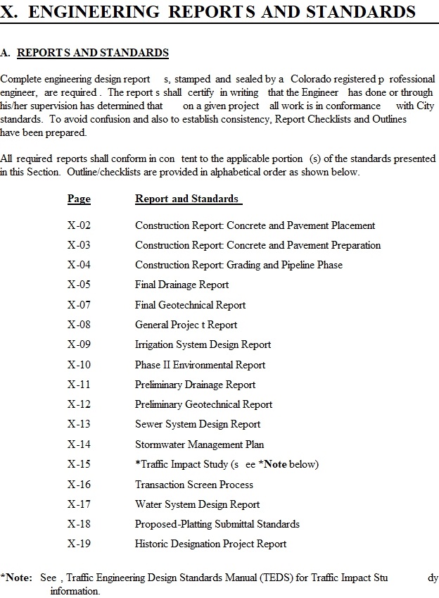
Part Three consists of Sections VII through XI, which define the standards required for each submittal item on the Submittal Checklists. These standards are necessary to maintain consistency and reference to them will assist in understanding what is expected by review agencies.
2. Typical Use. The developer should use this manual to determine the process that is involved in the design/application and also construction of a project. Based on the type, location and surrounding circumstances a project-specific submittal checklist is completed by the Planner, Development Engineer, Traffic Engineer and Fire Department and given to the applicant prior to application submittal. The Submittal Checklist uses truncated names such as “Landscape Plan” or “Roadway Plan and Profile.” Adjacent to each is a citation to the SSID manual wherein the developer can find a complete description, checklist or outline of what the item, drawing or report should entail. Submittal items shall be prepared and submitted in the format identified in the SSID manual. Failure to prepare and/or submit as required may result in the application submittal and/or project being rejected.
B. CITY DEVELOPMENT STANDARDS
List of Adopted Plans and Policies to be Considered/Followed
When Submitting a Development Project
ADOPTED PLANS AND POLICIES |
- Parks & Recreation Master Plan - Orchard Mesa Neighborhood Plan - Growth Plan - Corridor Guidelines - Urban Trails Master Plan - Grand Valley Circulation Plan - 24 Road Corridor Plan - Other adopted Manuals, Guidelines & Plans |
ZONING AND DEVELOPMENT CODE (The Code is frequently revised and updated - call 970/244-1430 for the latest information) |
- Development Regulations - Subdivision Regulations - Zoning - General Regulations |
SUBMITTAL STANDARDS FOR IMPROVEMENTS AND DEVELOPMENT (SSID) |
- Application Submittal Standards - Submittal Item Standards |
STORMWATER MANAGEMENT MANUAL (SWMM) |
- Drainage Requirements and Criteria - Erosion Control - Stormwater Management - Surface Water Quality |
STANDARD CONTRACT DOCUMENTS FOR CAPITAL IMPROVEMENTS CONSTRUCTION |
- Road, Bridge, and other Surface Work - Standard Details - Utility, Drainage, and Pipeline |
TRANSPORTATION ENGINEERING DESIGN STANDARDS (TEDS) |
- Street Classification - Geometric Design - Traffic Studies - Parking - Traffic Controls - Access Design |
WATER, WASTEWATER, AND PIPELINE DESIGN STANDARDS (No scheduled release date) |
- Water Distribution Systems - Pumping and Lift Stations - Sewage Collection Systems - Pipeline Design |
C. DEFINITIONS
1. Acronyms.
BMP Best Management Practice
CCR Covenants, Conditions and Restrictions (Also see page VII-2)
CDHPE Colorado Department of Health and Public Environment
CDOT Colorado Department of Transportation
CDPS Colorado Discharge Permit System (Colorado Department of Health’s version of EPA’s NPDES)
CGS Colorado Geological Survey
COE Corps of Engineers
DIA Development Improvements Agreement
DOW Department of Wildlife
EPA Environmental Protection Agency
GIS Geographical Information System
NPDES National Pollutant Discharge Elimination System
ODP Outline Development Plan
PA/SI Preliminary Assessment/Site Investigation (Level 1 Environmental Site Assessment)
PE Registered Professional Engineer
QA Quality Assurance (See page VI-1)
QC Quality Control (See page VI-1)
REPA Registered Environmental Property Assessor
RI/FS Remedial Investigation/Feasibility Study (Level 2 Environmental Site Assessment)
ROW Right-of-Way
SSID Submittal Standards for Improvements and Development
SWMM Stormwater Management Manual
SWMP Stormwater Management Plan
TEDS Transportation Engineering Design Standards
USGS United States Geological Survey
Additional abbreviations which are specific to drafting, surveying, and roadway design are provided on pages VIII-4 through VIII-10 “Drafting Abbreviations” and “Drafting Symbols.”
2. | General Terms. |
City | City of Grand Junction, Colorado
| |
Code | Zoning and Development Code
| |
Community Development Department | Refers to the City of Grand Junction Community Development Department
| |
Construction Drawings | Drawings which contain adequate detail and specifications of proposed facilities to allow construction.
| |
Developer | The terms “Developer,” “Applicant” and “Petitioner” are used synonymously herein and refer to the person, persons or firm requesting approval of a proposed development.
| |
Development | Processes which involve subdividing, rezoning, variances, permits or planning clearances as defined in the Zoning and Development Code.
| |
General Meeting | The general meeting allows the applicant to meet informally with the staff to discuss a project and provide feedback and ideas. Based on the detail and information provided, the staff will give direction on the merits, procedures and issues on a proposed project. A development application may not be submitted until after the general meeting is completed (see Section 2.2.B.1.a in the Zoning and Development Code). A General Meeting is required for the following processes: Major Site Plan Review, Conditional Use Permits, some Variances, Major Subdivisions and Planned Developments or any combination of development applications as determined by City Staff.
| |
May |
A permissive condition, where no requirement for design or application is intended.
| |
Monumented Land Survey | A land survey prepared by a professional land surveyor in which monuments are either located or set marking the boundaries of a specified parcel of land, lots and Subdivisions. See §38-50-101, et seq., C.R.S. and §38-51-101, et seq., C.R.S. for the rules and requirements for plats and land surveys.
| |
Non-Construction Drawings | Drawings which provide useful information regarding adjacent sites, land use and zoning, lotting, and existing and proposed facilities, but are not prepared for the purpose of being used as a construction document.
| |
Planned Zone | An area of land zoned in accordance with Chapter 2, Section 2.12 and Chapter 5 of the Code.
| |
Plat | A drawing delineating property boundaries, lots and subdivisions. See §38-51-101 et seq. C.R.S.
| |
Pre-Application Conference | A pre-application conference with City staff is highly recommended, but not required, for most subdivisions, multi-family, commercial and industrial developments. See Section 2.2.B.1.b in the Zoning and Development Code. | |
Qualified Person
| A “Qualified Person” is a person responsible for construction of development projects (see Section VI.1). The Engineer of Record for the project must approve of the “Qualified Person.”
| |
Review Agencies | Refers to those agencies that review development applications, including City staff. |
Shall | Where certain requirements are described with “SHALL,” it is mandatory that these requirements be met.
|
Should | Where the word “should” is used, it is considered to be advisory usage, recommended but not mandatory.
|
Staff | Refers to City Staff. City Staff does not represent the applicant or the applicant’s interest(s). |
III. APPLICATION PROCESS
A. CLASSIFICATION OF DEVELOPMENTS. Developments are classified by the Code based on zoning, use and project review type. Staff determines the classification at the General Meeting or Preapplication Conference. For each development classification an application process is established by these regulations.
B. OVERVIEW OF CLASSIFICATIONS. The SSID manual, which is Section 6.8 of the Zoning and Development Code, establishes submittal requirements. The Zoning and Development Code specifies types of permits and review.
C. APPLICATION SEQUENCE. Approval of a Development may require one or more application process. As an example, for a major subdivision both a preliminary and final application process is required. A Conditional Use application may be required to precede a Site Plan Review. Separately or in conjunction with another application a rezone, vacation, variance or revocable permit may be required or desired. An overview of the sequential order of these various applications, their inter-relationship and who is involved in the review process of each, is outlined on the Application Sequence Chart on page III-02
D. APPLICATION PROCESS. The application and review process for all development applications is in Chapter 2 of the Zoning and Development Code. Summary application sequence charts are on pages III-03 and III-04 of the SSID manual.
IV. APPLICATION PHASE SUBMITTALS
A. SUBMITTAL REQUIREMENTS. Whether a development becomes a valuable asset or a liability to the community is largely dependent upon how well the project is planned, designed and constructed. Once a Development is committed to paper it will be reviewed by many agencies having a broad diversity of expertise and interests. In this manner, each Development is benefited by a “team” review.
B. MINIMUM SUBMITTAL REQUIREMENTS. The Developer will be advised of the application requirements during the Pre-application or General Meeting Conference. A Pre-application conference is highly recommended, but not required, for most subdivisions, multi-family, commercial and industrial developments; a General Meeting is mandatory for the following applications: Major Site Plan Review, Conditional Use Permits, some Variances, Subdivisions and Planned Developments or any combination on development applications as determined by staff. A Submittal Checklist(s) for the type of development proposed will be completed by Staff. The Staff may add to or delete from the requirements of the Submittal Checklist as appropriate for the development proposed. Review agencies may require the Developer to submit maps, drawing, documents and/or information that was not required in the Submittal Checklist. The Developer is always encouraged to discuss the proposed project with the/any review agency(ies) prior to submittal of a development application to the City.
C. CHECKLISTS. Submittal Checklists, subject to B above, have been prepared for the developments listed below:
(Note: Not all applications listed below require a General Meeting or Pre-Application Conference.)
Section-Page |
Checklist | Section-Page |
Checklist |
IV-02 | Change of Use Review | IV-16 | Revocable Permit |
IV-03 | Concept Plan | IV-17 | Rezone |
IV-04 | Conditional Use Permit | IV-18 | Rezone - Preliminary Plan |
IV-05 | Conditional Use Permit - Gravel Pit | IV-19 | Site Plan Review, Major |
IV-06 | Conditional Use Permit - Site Plan Review | IV-20 | Site Plan Review, Minor |
IV-07 | Conditional Use Permit - Telecommunications Tower | IV-21 | Site Plan - Simple Subdivision |
IV-08 | Condominium Plat | IV-22 | Subdivision, Major - Preliminary |
IV-09 | Floodplain Permit | IV-23 | Subdivision, Major- Final |
IV-10 | Growth Plan Amendment | IV-24 | Subdivision, Simple |
IV-11 | Historic Designation | IV-25 | Temporary Use Permit |
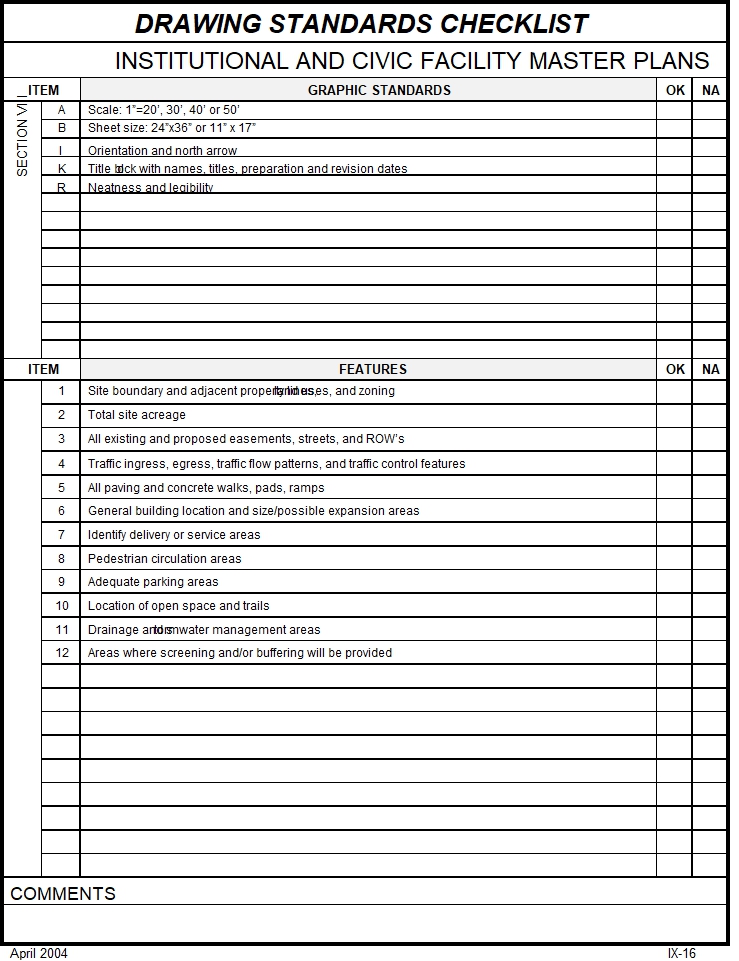
IV-12 | Institutional & Civic Facility Master Plan | IV-26 | Vacation of: Easement, ROW, Plat |
IV-13 | Outline Development Plan (ODP) | IV-27 | Variance |
IV-14 | Planned Development - Preliminary | IV-28 | Variance – Sign |
IV-15 | Planned Development - Final |
V. SUBMITTAL FORMAT
This section describes the format that shall be used when submitting an application.
A. GENERAL REQUIREMENTS
1. Fees. An application fee is due at the time of project submittal. Checks shall be made payable to the City of Grand Junction.
2. Collated Packages. Submittals shall be collated and prepared (labeled and contain the necessary documents) for each reviewing agency. If the reviewing agency requires more than one copy, the package shall contain the appropriate number of collated copies.
3. Order of Submitted Items. Documents in submittal packets shall be in the order shown on the Submittal Checklist.
4. Securing Packages. Submittals shall not be made in folders, envelopes or binders. Documents may be secured by binder clips or rubber bands.
5. Submittal Checklist. A copy of the Submittal Checklist prepared for the Developer in the Pre-application Conference or General Meeting shall precede the Review Agency Cover Sheet in submittal made to the Community Development Department.
6. Review Agency Cover Sheets. All submitted packages shall have a Review Agency Cover Sheet. The upper portion of the cover sheet shall be completed prior to submittal.
7. Original Signatures. When/if an original (document, drawing or signature) is required the original(s) shall be submitted in the Community Development submittal package. Copies of originals are acceptable for other recipients.
B. DRAWINGS. Depending upon the drawing type and recipient, drawings may be folded, rolled, bound or individually submitted as further described in this paragraph.
1. Folded. Folded drawings shall have the title block facing up in the lower right hand corner. Folds shall be such that the final size measures no more than 9" by no more than 12".
2. Rolled. Rolled drawings shall be stapled along the left edge, rolled such that the drawing side is facing out and the title block is exposed. The roll shall be rubber banded.
3. Application and Design Drawings. Informational and construction drawings shall be presented as follows:
a. Informational Drawings. Vicinity Sketches, Location Maps, Preliminary, Composite, Utility and Concept Plans, ODPs and Elevation Drawings are informational drawings. Informational Drawings shall be submitted and folded separately.
b. Construction Drawings. Drawing Cover Sheets, Grading and Stormwater Management Plans, Plan and Profile drawings, Roadway cross-section sheets, Detail drawings, Landscape Plans, and Site Plans are construction drawings. Construction Drawings shall be submitted as follows:
1) Submittals to Engineering shall be as a set in a roll;
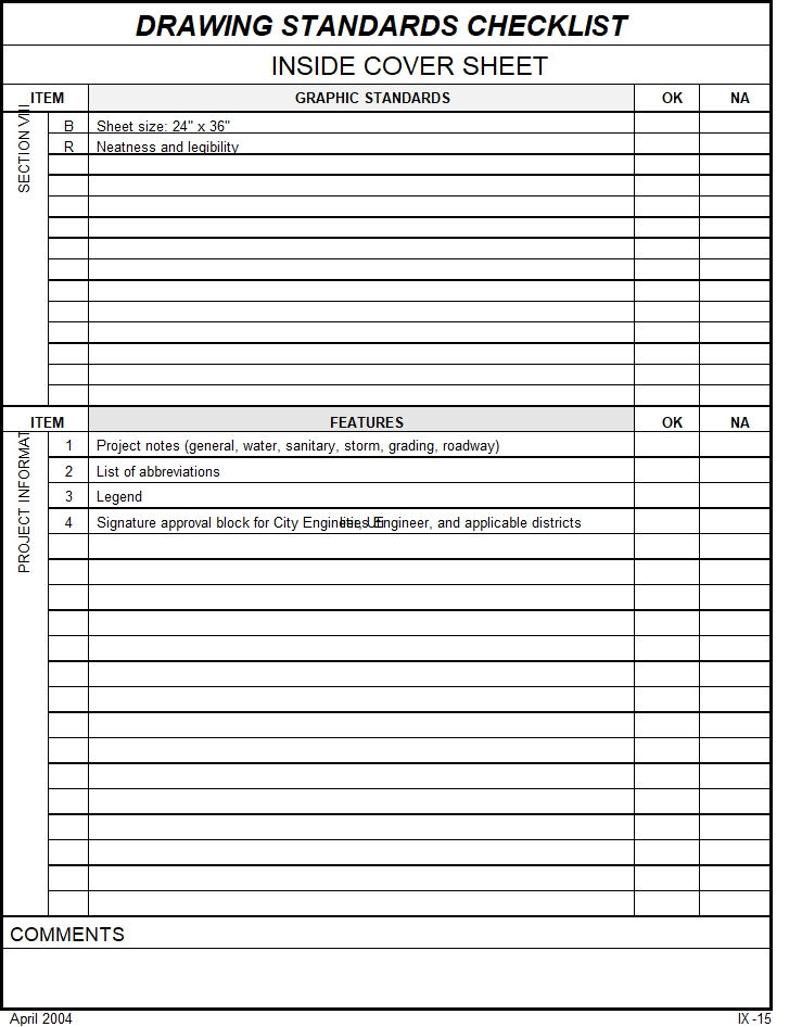
2) Submittals to Community Development shall be folded and stapled together as a set and an Inside Cover Sheet (see IX-15) shall be provided for all plan sets which exceed five pages; and
3) For review agencies other than City Engineering and Community Development, plans shall be folded individually.
4. As-Built Sketches. Red-lined prints of the approved plans shall be submitted to Engineering individually folded.
5. As-Built Drawings As-built drawings and Final Plats shall consist of sealed prints and mylars. All final plat and as-built information must be submitted to the City on an electronic disk suitable for use with a personal computer in a format compatible with DFX and DWG files.
C. FORMAT CHECKLIST. The following Format Checklist is provided as an aid in preparing applications for submittal.
FORMAT CHECKLIST |
GENERAL REQUIREMENTS
Complete ( X )
____ 1. Fees Application fee, with check made payable to the City of Grand Junction. ____ 2. Collated Packages Collated sets are provided for each recipient of a submittal package. ____ 3. Order of Submitted Items Items should be submitted in the order presented on the Submittal Checklist. ____ 4. Securing Packages Bound with rubber bands or binder clips, NOT folders, envelopes, or 3-ring binders. ____ 5. Submittal Checklist Placed atop the Review Agency Cover Sheet in the Community Development package. ____ 6. Review Agency Cover Sheets The top section is filled out, and is provided in all packages where required by the Submittal Checklist. ____ 7. Original Signatures Items having original signatures shall be placed in the Community Development package.
DRAWINGS
____ 1. Folded Drawings Final size is between 8 1/2" to 9" and 11" to 12". The title block faces up in the lower right hand corner. ____ 2. Rolled Drawings Banded, with drawing facing out. ____ 3. Format ® Information drawings individually folded ® Construction drawings to Engineering rolled (may include plat) ® Construction drawings to Community Development folded or rolled as a set ® Site Plans to other review agency(ies) folded individually ____ 4. As-built Sketches Red-lined prints individually folded ____ 5. Record As-built Drawings and Plats Mylars rolled, AutoCad disks labeled, electronic version emailed to GIS department.
Note: For definition of the above requirements, please reference pages V-1 and V-2. |
VI. CONSTRUCTION PHASE SUBMITTALS
A. QUALITY IS REQUIRED. Adequate quantity and quality of observation and testing during the construction process is essential to achieving a quality product. Consequently, the City requires Quality Control and Quality Assurance observation and testing during the construction of:
1) Facilities that will become public, such as streets, sidewalks, water, sewer and storm drains; and
2) Facilities that may ultimately impact the public at large, such as Best Management Practices, overlot grading, private detention/retention basins and storm water collection and conveyance.
B. THE DEVELOPER IS LEGALLY RESPONSIBLE FOR QUALITY CONTRUCTION OF THE DEVELOPMENT PROJECT. The Developer, the engineer and/or contractor as the developer’s agent(s) shall implement the procedures, methods, testing, surveying and observation that are required by the City to insure that the work conforms to all City specifications.
C. THE DEVELOPER IS LEGALLY RESPONSIBLE FOR QUALITY ASSURANCE (QA) OF THE DEVELOPMENT PROJECT. Quality Assurance, for the purposes of these regulations means that a Qualified Person is responsible for developing and supervising systematic observation of the work, testing of the materials and the compaction of the materials that are required to be compacted, all of which shall be performed to, with and be verified by the Qualified Person upon completion to be in conformance with City-approved plans and specifications.
(12-25-102(10), C.R.S. defines “practice of engineering” to include the "....observation of construction to evaluate compliance with plans and specifications...")
D. CITY INSPECTION. In addition to Quality Control and Quality Assurance provided by the Developer and his agent(s), the City may perform spot inspections of the construction of any Facilities. The Developer shall provide the City a copy of its construction activity schedule prior to commencement of work. As time permits, a City inspector may make periodic inspections of the work. Such inspection, or not, of the work by the City does not relieve the Developer of its obligation(s) to observe, monitor and conduct necessary tests. The City Inspector and/or City Development Engineer may require work to be uncovered or removed if Quality Control/Quality Assurance to City standards is not demonstrated to the satisfaction of the City Inspector and/or City Development Engineer.
E. CONSTRUCTION SEGMENTATION. As construction proceeds, the quality or acceptability of work often depends upon the quality of work which precedes(ed) it. Any or all work on a development may be stopped unless and until QC/QA observations and testing City approval(s) of the same are given.
F. CONSTRUCTION PHASE SUBMITTAL CHART. A form has been prepared which identifies various steps of construction activity and corresponding required submittals. The submittals may be varied depending on the type and size of the project involved. The form will be completed by Staff and submitted to the Developer. Only those items with shaded-in circles will be required.
CONSTRUCTION PHASE SUBMITTAL CHECKLIST |
Location: Project Name: _________________________________ |
STEP |
ACTIVITY |
SUBMITTAL ITEMS |
REFERENCE |
1 |
Pre-construction |
l City Approval of Construction Drawings l Pre-construction Notice m Work within Public ROW Permit m Improvements Agreement/Guarantee • ________________________________________ m |
VII-4 VII-5 VII-6 VII-2
|
2
____________ *Sign and date
____________ *Sign and date |
Grading Street Rough Cut Sanitary Sewer Water Irrigation Other Utilities Sub-grade Base Course Concrete Placement
OKAY FOR CONCRETE PTC = Prior to Concrete
OKAY FOR PAVEMENT PTP = Prior to Pavement |
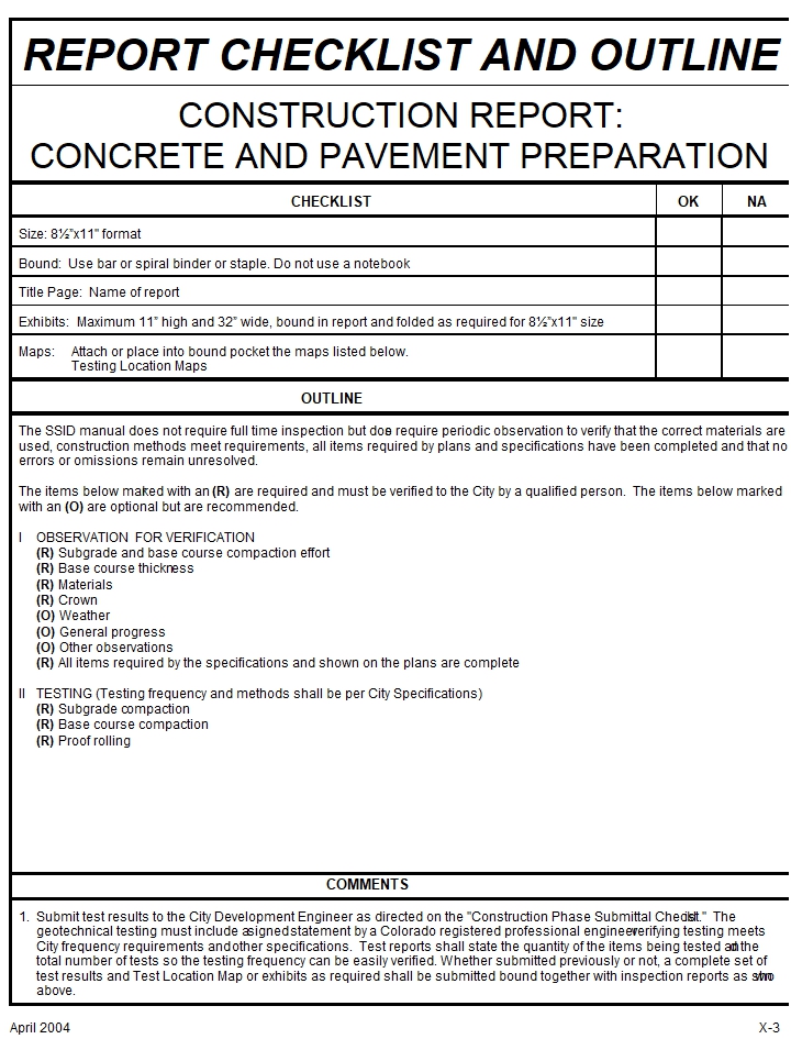
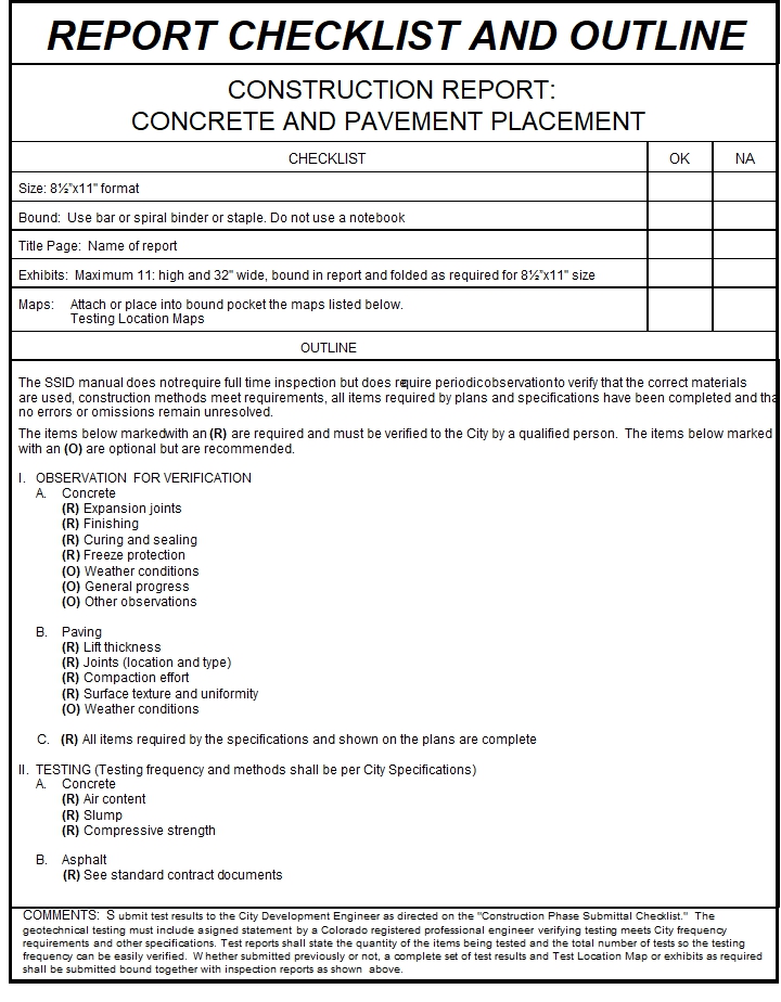
• Construction Report: Grading and Pipeline Phase. PTC m Construction Report: Concrete and Pavement Preparation. PTC & PTP m Revised Pavement Design (if necessary). PTP • Request City Lamping of Sewerline. PTC • Complete Compaction Tests for all utilities, subgrade, and base course under concrete. All at once just prior to concrete construction. PTC • Letter from water purveyor stating passage of pressure and disinfection tests. PTP • Sanitary sewer pressure test after wet utility installation. PTP • Redlined Sanitation Sewer As-Built Drawings. PTC • Redlined Storm Sewer As-Built Drawings. PTC m Complete Compaction Tests for base course under asphalt. All at once just prior to pavement. PTP • Letter from sewer purveyor stating passage of their tests. • ________________________________________ |
X-4 X-3
VII-6
VII-5
VII-6 VII-6 VII-6 |
3 |
Asphalt Pavement Dry Utilities Traffic Control Facilities Monumentation Permanent On-Site Benchmark (Subdivisions Only) |
m Complete QA Reports for asphalt and concrete. m Construction Report: Concrete and Pavement Placement m Complete Set of As-Built Drawings • Request for City Initial Inspection • Letter from PE stating passage of sanitary sewer pressure test after dry utility installation. m |
X-2
IX-3 to IX-7 VII-6 VII-6 |
4 |
Warranty Period Maintenance Agreement |
• Request for City Final Inspection • Agreement and Financial Guarantee |
VII-6 **ZDC |
NOTES: 1. Only those submittal items, which are preceded by a shaded-in circle, are required for the project. At the time of construction drawing approval, City Engineering will submit to the developer one signed approved set of reproducible drawings. A copy of this form, which has been completed for the specific project and one completed copy of Form VI-4 and VI-5 will be transmitted to the developer at the preconstruction meeting. 2. City Engineering approval of submittal items is required prior to commencement of subsequent steps. The City will make every effort to provide timely approvals in order to accommodate construction schedules. If information is submitted for Step 2 in a timely manner as construction proceeds, then City Engineering review of remaining items may be done within two working days. 3. The “OKAY FOR CONCRETE” and “OKAY FOR PAVEMENT” lines must be signed or other written notification given by the Construction Inspector or the Development Engineer prior to placing concrete or asphalt. No concrete or asphalt shall be placed without these signatures. IT IS THE DEVELOPER’S RESPONSIBILITY TO OBTAIN THESE SIGNATURES. |
*Distribution for Signatures: Construction Inspector and Development Engineer
**ZDC = Zoning and Development Code

City of Grand Junction
Construction Approval & Progress

Project Name:
Location:
Developer:
Engineer:
Planner: ___________________________________________________________________
A Qualified Person is required to verify that construction of public improvements has been accomplished in accordance with City standards, specifications and testing methodology.
Date Construction Plans Approved: __________________ Engineer Initials: _____________
Submit reproducible drawings for approval and signature. Return 4 sets of full-sized prints. Distribution: Development Engineer (2 copies), City Inspector (1 copy), Community Development (1 copy).
Improvement Agreement in Place: _______________
Pre-Construction Meeting: ________________________
1. Attendance by developer's engineer, Qualified Person, surveyor, contractor(s), testing lab, City engineering representative and a City inspector is required.
2. Submit list of contractors and starting dates/construction schedule.
3. Submit quality assurance plan for testing and inspection. A test location map will be required.
4. Notification of City inspector 24 hours prior to commencement of any work is required.
Permit for Construction and Installation of Facilities in Public Right-of-Way required: _________________
City inspection of work does not relieve Developer and/or the developer’s engineer of their responsibility to observe, monitor, test and verify the facilities meet City standards.
 City of Grand Junction
Submittal Requirements for
Initial Acceptance of Improvements

The following items must be submitted prior to initial acceptance of streets, drainage, and utilities by the City of Grand Junction.
____As-Built Drawings (Reference SSID IX-3, 4, 5, 6, 7)
è Sealed by a Professional Engineer, having supervised the work, registered in the State of Colorado
è Four paper copies
è One Mylar copy
è One disk with drawing files or emailed to the Planner
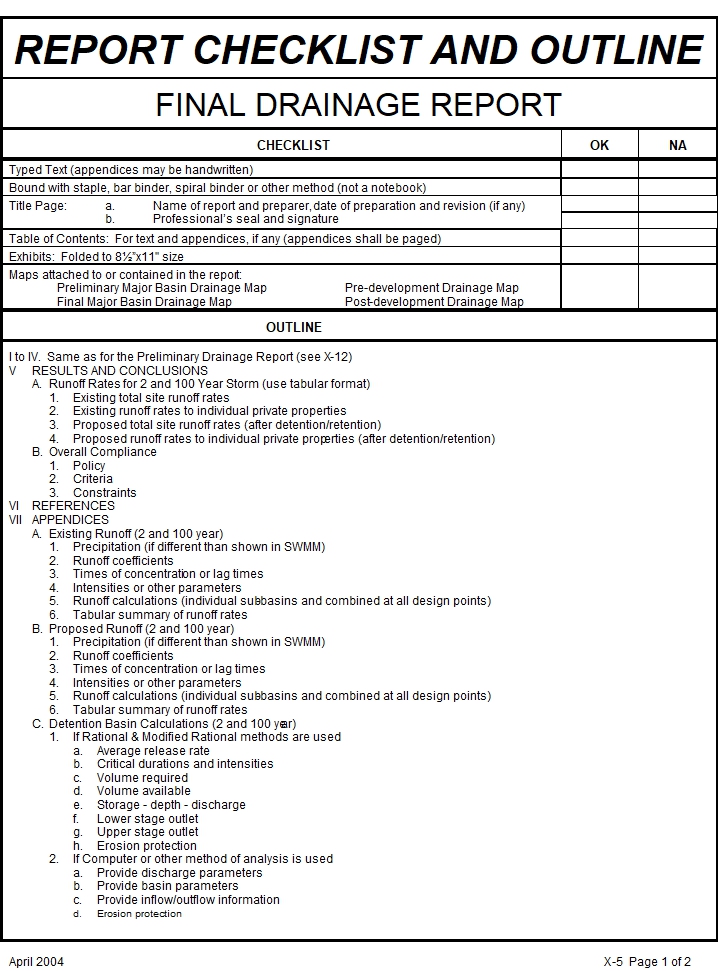
____Report (Reference SSID X-2, 3, 4)
è Daily diary
• Applicable correspondence
• Letter verifying work was performed according to approved plans and specifications
____Bound Testing Results
• Testing location maps (if not submitted earlier)
• Compaction tests for all aspects of the project ( if not submitted earlier)
• Applicable proctors and other lab tests performed (if not submitted earlier)
• Asphalt tests and lab results
• Concrete tests and break results
____Verification of Detention/Retention Basin/Storm Sewer System (Reference SSID IX-04)
• Sealed by a Professional Engineer
Note: A one-year warranty period begins once public facilities are initially accepted by the City of Grand Junction. Any defects or deficiencies that occur during this period must be corrected by the developer.
SUBSTANTIAL COMPLETION INSPECTION CHECKLIST
City of Grand Junction, Colorado
250 North Fifth Street
Grand Junction, Colorado 81501-2669
FAX (970) 256-4031
Project:
Date:

ÿ Pavement
ÿ Concrete
ÿ Manholes
ÿ Signs
ÿ Lighting
ÿ Site Grading
ÿ Other

ÿ Water Lines
ÿ Sewer Lines
ÿ Inlet Structures
ÿ Detention Facilities with letter certifying capacity
ÿ Outlet Structures
Inspected by:
_____________________________ _____________________________
City Development Engineer Developer or Representative
Final Acceptance of the Streets and Drainage Facilities will be made when the above items have been corrected and inspected. Please call 970/244-1430 when ready for final acceptance.
Distribution - White: Developer Yellow: Development Engineering Pink: Engineering Lab/Inspector Goldenrod: Community Development
VII. GENERAL ITEMS
A. ADMINISTRATIVE ITEMS
1. Annexation Documentation
The following documents are necessary to prepare/submit an annexation petition.
a. Assessors Map showing the subject property and all other property adjacent to the subject property which are owned by the same owner;
b. Tax ID number for the subject property to be annexed;
c. Legal description of the subject property to be annexed;
d. A copy of the owner’s deed;
e. Complete list of owners’ names and addresses if the owners do not reside on the property to be annexed.
These documents are submitted to the Community Development Department.
The annexation petition is drafted and returned to the property owner(s) for signature(s) in the presence of a Notary Public. The petition is then filed with the Community Development Department. Applicants will be advised within 10 working days of the dates and times of the meetings concerning the annexation application.
2. Application Fee. The fee will be determined at the General Meeting/Pre-Application Conference. Fees are based upon the classification and specific conditions of the proposed project. The fee covers the costs of processing, staff review and legal notice for the proposal and is nonrefundable. Checks should be made payable to the City of Grand Junction.
3. Application Form. The applicant shall complete the "Property Owner," "Developer" and "Representative" information and sign where indicated. The form with original signatures must be in Community Development's submittal packet. Copies are acceptable for other review agencies.
4. Appraisal of Vacant Land. For all development requiring payment into the parks/open space acquisition and/or development fund, an appraisal of fair market value of the unimproved land is required. The appraisal shall be at the Developer's expense and performed by an accredited certified MAI appraiser licensed by the State of Colorado.
5. Avigation Easement. A dedication and/or conveyance of navigable airspace to an infinite height above the surface of the grantor's property. An avigation easement shall include a release by the grantor binding on his successors and assigns, which shall run with the land, of all claims or causes of action, now or in the future, which arise from noise, vibrations, smoke, fumes, glare, fuel particles or any other cause by the operation of aircraft.
6. Common Elements Agreement(s). An agreement providing for the long-term use and maintenance of common space within a development. This may be included in the Covenants, Conditions and Restrictions.
7. County Treasurer's Tax Certificate. A current original (or verified current copy) of the Treasurer's Certificate of taxes due. (A tax certificate is obtained from the Mesa County Treasurer's Office. There is a charge for the document.) The City may require an applicant to pay unpaid and due taxes prior to City approval of an application.
8. Covenants, Conditions, and Restrictions A draft copy of Covenants, Conditions and Restrictions must be provided if there are common elements. Proof of incorporation of an Home Owner’s Association (HOA) filed with the Secretary of State must also be provided.
9. Conveyances. See Deed.
10. Condominium Plat. The final plat, which is recorded and any other instruments referred to in the condominium declaration, that depicts the size, location, area, horizontal and vertical boundaries and volume of each condominium unit, as well as the nature, location and size of the common elements.
11. Deed. A document conveying and evidencing conveyance of land or conveyance of an interest in land. The City may specify the form (such as Warranty Deed, Special Warranty Deed, Quit Claim Deed, etc.) of any and all deed(s) submitted or required to be submitted. Proposed deed form(s) (for conveyance of land or an interest in land to the City) shall be submitted before a conveyance is proposed (with a development application if as part of that application the developer is proposing a conveyance to the City). Recording of deed(s) and payment of associated fees are the Developer's sole responsibility. Final approval of any project is contingent upon the execution and recordation of any and all required deed(s).
12. Development Improvements Agreement (DIA) and Guarantee
a. Agreement The DIA consists of a detailed, itemized contract with the Developer for the construction of public improvements, as well as the landscaping required for a development; quantities and costs shall be established. The agreement shall be approved by Community Development Director and the Public Works & Utilities Director or their designees. The agreement shall include a date for completion of all improvements. A memorandum shall be recorded prior to recording a plat, issuance of a Planning Clearance or commencement of a use, whichever comes first. The developer shall pay all recording fees.
b. Guarantee The guarantee shall secure the construction of the public improvements and/or landscaping as shown in the agreement. Acceptable guarantees consist of cash, a letter of credit or a disbursement agreement.
c. Release of Guarantee and Agreement The Developer shall submit a written request for release of the DIA or for the portion which has been accepted and for which the required maintenance guarantee has been provided. A request to release a DIA shall be accompanied by written verification, in a form as required by the City Attorney, that there are no outstanding judgments or materialmens’ or suppliers liens against the property. The Director and the City Attorney shall review and if appropriate approve the request. Release of the DIA, in whole or in part, does not constitute a Certificate of Completion and Release of Responsibility. The Developer shall pay all recording fees associated with the Recording Memoranda to release the DIA.
13. Easement. A dedication to the City and/or conveyance by deed of an interest in land, (to the City of Grand Junction or other appropriate agency,) for the use of said interest in land, for specific purposes, under such terms, conditions and requirements as established.
14. Evidence of Title/Title Commitment
a. ODP's and Major Subdivisions: Preliminary. A current (no less than 90 days old at the time of any submittal) commitment for title insurance which shall: set forth the names of all owners of the property included in the plan and a list of all persons who have/may have an interest in the land via liens and encumbrances, including mortgages, judgments, easements, contracts and/or agreements of record which effect the property covered by the plan(s). The City may require an updated commitment for title insurance at any time.
b. Simple Subdivisions and Major Subdivisions: Final A current (no less than 90 days old at the time of any submittal) commitment for title insurance which shall: set forth the names of all owners of the property included on the plat and a list of all persons who have/may have an interest in the land via liens and encumbrances, including mortgages, judgments, easements, contracts and/or agreements of record which effect the property covered by the plat. If the title commitment discloses mortgages, judgments, liens, easements, contracts or agreements all holders, owners and others that claim a right, title or interest in the property by or through the same shall be required to approve the plat, in writing by signing and notarizing a ratification of the plat and otherwise releasing and/or subordinating their interest(s) before the plat will be recorded. The City may require an updated commitment for title insurance at any time.
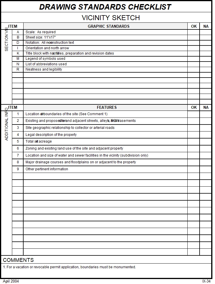
15. Legal Description A typed legal description of all properties involved in the proposed development. This must be a separate document from that which may be provided on drawings and sent via electronic mail to the Community Development Department.
16. Location Map/Vicinity Map An 11" x 17" location/vicinity map with the subject property outlined in red.
17. Name and Address List A list of all names and addresses of all property owners within 500 feet of all boundaries of the property. The width of public rights-of-way, easements, canals or other waterways shall not be included when determining the 500-foot radius. The Mesa County Assessor's records shall be used to determine all ownership(s) within the radius. The City will provide a name and address list.
18. Planning Clearance A form provided by the City. The applicant shall complete the top portion and sign and date the bottom.
19. Power of Attorney A form provided by the City. The property owner’s signature is required.
20. Review Agency Cover Sheet A form provided by the City. The Developer must provide the required information.
21. Right-of-Way Right-of-Way dedications are defined as a dedication and/or conveyance of land to the City of Grand Junction or other government agency, for the use and/or ownership of the land for the construction, improvement and maintenance of public roads, highways, accesses and other public installations and/or improvements. Right-of-Way may also mean and refer to any platted or designated public street, alley, lane, parkway, avenue, road or other public way, whether or not it is constructed or has been used as right-of-way or for any other public purpose. The Developer may be required to verify that there is adequate right-of-way existing to serve the project and if not to provide the same.
22. Sign Plan/Sign Package
Chapter Four of the Code addresses among other things, sign regulations. A comprehensive sign design, describing all proposed signage, including, but not limited to size, letter height and method of illumination must be provided. Sign permits are required and signs must be erected by licensed sign contractors within the City.
23. Site Data Table The Site Data Table provides information regarding the proposed land use(s) of the developing property. The table depicts the proposed square footage(s) for each use(s). A site data table establishes the size of the structure(s) with their prospective use(s), existing structure(s) on the site, retention area(s), hard surface area(s) (such as sidewalk and parking), landscaping area(s) and undeveloped ground.
24. Submittal Checklist This form is provided to the Developer after the Pre-application Conference or General Meeting. The Submittal Checklist shows the specific submittal requirements for a particular project. The original (completed) form is to be returned in the Community Development Department submittal packet.
B. MISCELLANEOUS ENGINEERING REQUIREMENTS. Engineering requirements (that are not presented to/prepared for the City in the form of a drawing or a report) are noted here.
1. 404 Permit Development applications that will or might impact waters of the United States including “jurisdictional wetlands” are reviewed by the Army Corps of Engineers (ACE). An original or verified copy of the ACE approved or issued permit, shall be submitted to Community Development as a part of the Development Review process.
2. CDOT Access Permit Development that will require additional or modified access to a State Highway requires approval and a written permit from the Colorado Department of Transportation (CDOT). Highways 6, 6 Bypass (North Avenue), 24, 50, I-70, I-70 B, 141 and 340 are under CDOT jurisdiction. The Access Permit is negotiated by and between the developer and CDOT and a Notice To Proceed (NTP) issued by CDOT prior to plan approval.
As of January 2004 an Application for Access Permit may be obtained from CDOT at 222 South 6th Street or at 606 South 9th Street, Grand Junction, CO.
3. City Approval of Construction Drawings Development plans that have received all requisite approvals will be approved by Staff signature on the plans, by letter or both.
4. City Initial Inspection An inspection must be performed by the City after all developer-installed improvements are complete. If found to be acceptable, the warranty period on the improvements will begin.
5. City Final Inspection An inspection must be performed by the City after the warranty period expires.
6. Construction - Prior Notice Prior to the commencement of Construction, the Developer shall submit the following information to the City Development Engineer:
a. The correct number of copies of signed and sealed plans/specifications [which the City Development Engineer has stated in writing are acceptable for approval and/or as required are in final form on Mylar];
b. Development Construction Schedule;
c. List of Contractor(s) to be used on the development and telephone number(s);
d. The name and telephone number of the testing laboratory that will provide testing;
e. The name and telephone number of the developer's designated project manager and/or construction inspector; and
f. The name and telephone number of the Developer's designated Quality Assurance Person (see Page VI-1, Paragraph C).
7. Construction Schedules and Updates The construction schedule shall be sufficiently detailed to show commencement, duration and completion for each aspect of construction. If changes or delays occur, a corrected schedule shall be submitted to the City Development Engineer within 5 days of the change or delay.
8. Floodplain Permit A Floodplain Elevation Certificate (FEC) is provided by the Federal Emergency Management Agency (FEMA) on their website. The form must be completed by the Developer’s engineer and/or land surveyor. An original or verified copy of the FEC shall be submitted to Community Development as a part of the Development Review process. After construction, the FEC shall be submitted showing the final constructed elevation.
9. Flowline Grade Sheets These surveying grade sheets shall identify the street name, with stationing consistent with design drawings, showing design and "as-built" grades for gutter flowlines. Grades shall be obtained at all points that design grades are required on the approved drawings.
10. Industrial Pretreatment Any facility that will be contributing wastewater/process water (anything other than domestic waste) to the sanitary sewer system shall submit an application to the Persigo Wastewater Treatment Facility, Pretreatment Coordinator. A permit may or may not be required. An original or verified copy of the approved or issued permit, if any, shall be submitted to Community Development as a part of the Development Review process.
11. NPDES Construction Activity Permit In accordance with State and Federal regulations a NPDES (and/or CDHPE) permit is required where construction activity for all phases of a project will disturb more than one (1) acre of surface area of land. The Colorado Department of Health Water Quality Control Division processes applications. An original or verified copy of the CDHPE approved or issued permit, if any, shall be submitted to Community Development as a part of the Development Review process.
12. Red-Lined Sanitary Sewer As-Builts Sanitary - Sewer as-builts are required prior to paving. These must include invert elevations and slopes of each reach and stub-outs. Red- lined as-builts shall be followed up with the required final as-builts.
13. Red-Lined Storm Sewer As-Builts Storm sewer as-builts are required prior to paving. These must include invert elevations and slopes of each reach and stub-outs. These red- lined as-builts shall be followed up with the required final as-builts.
14. Sewerline Lamping and Pressure Testing Once the manholes and sewer line installations are complete and sub-grade and base course in roadways has been compacted preparatory to paving, the City will lamp the sewer line. Requests for lamping should be made by calling (970) 244-1555. The contractor shall pressure test to specifications provided by the City the sanitary sewer after lamping. After all concrete and paving is complete and after all telephone, gas, power, cable TV, etc., have been installed, the sanitary sewer shall be pressure tested again to the specifications provided by the City. The Developer’s engineer shall observe all pressure tests and when the line(s) passes write, sign and seal a letter stating that passing test results have been obtained.
15. Water Line Pressure and Disinfection Tests - Written Documentation from the water provider stating that passing test results have been obtained is required prior to paving.
16. Work Within Public ROW Permit A City right-of-way permit must be obtained from the City Engineer prior to commencement of cut, fill, utility work and/or traffic flagging/routing within a City ROW. If the Developer temporarily or permanently occupies City right-of–way, as if the Developer owns or exclusively controls the right-of-way, a revocable permit is required.
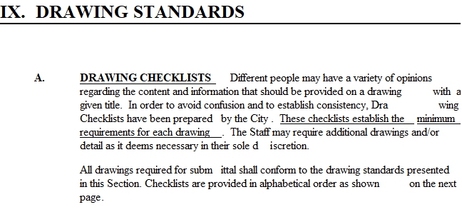
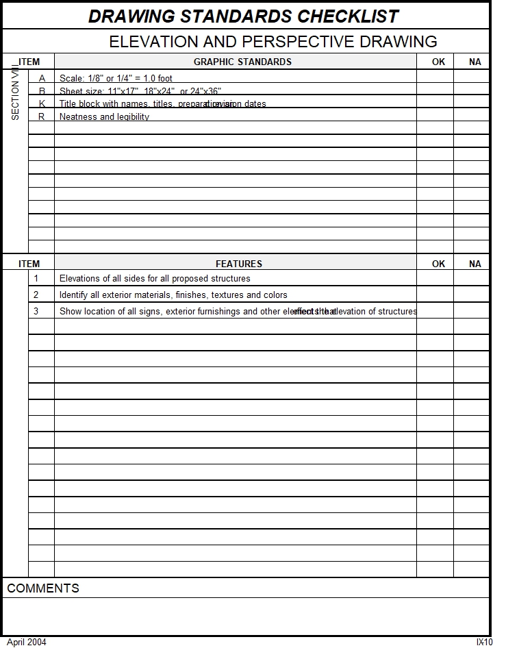
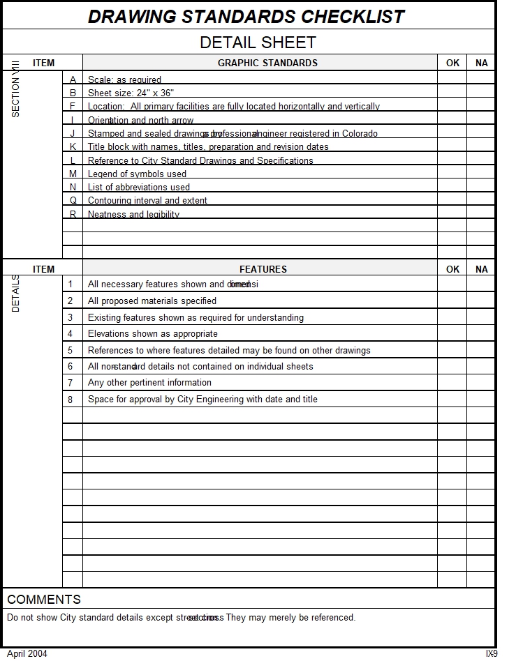
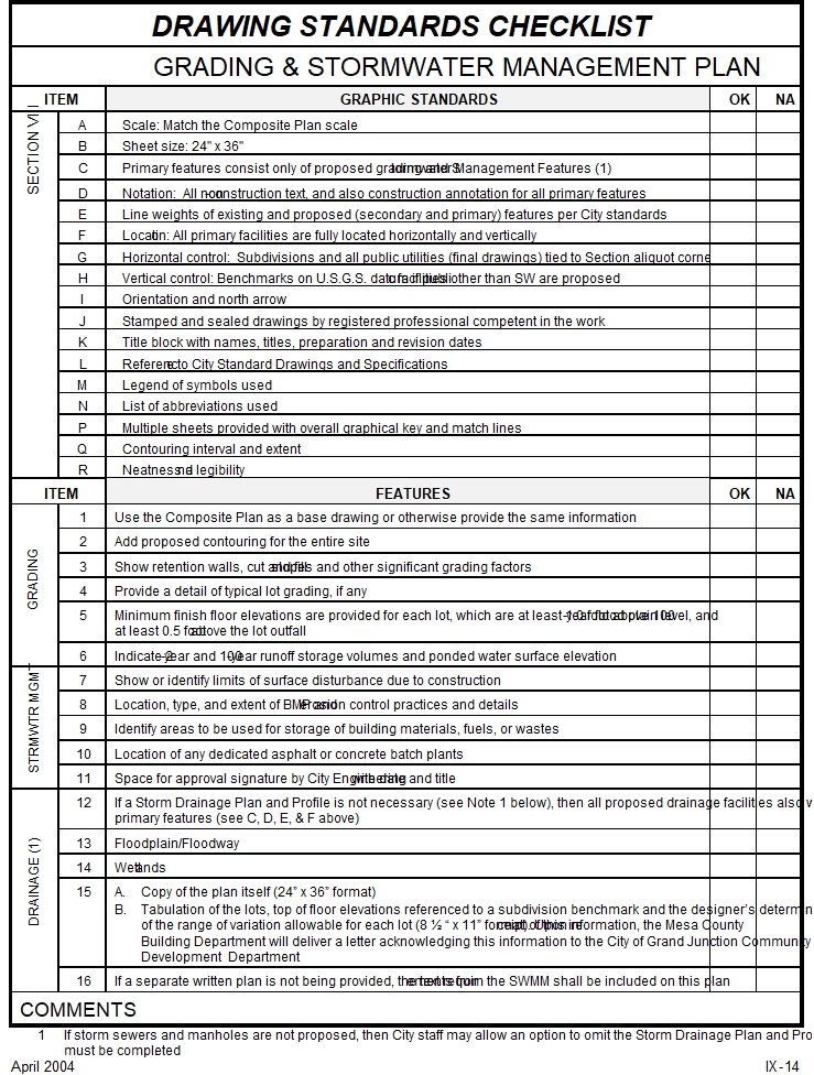
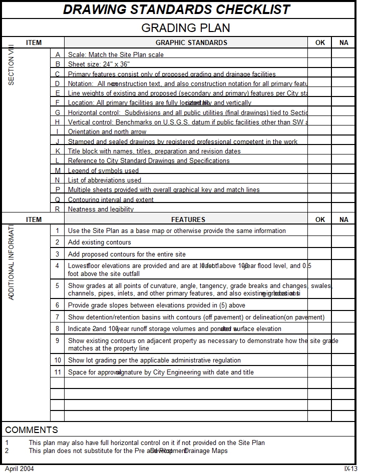
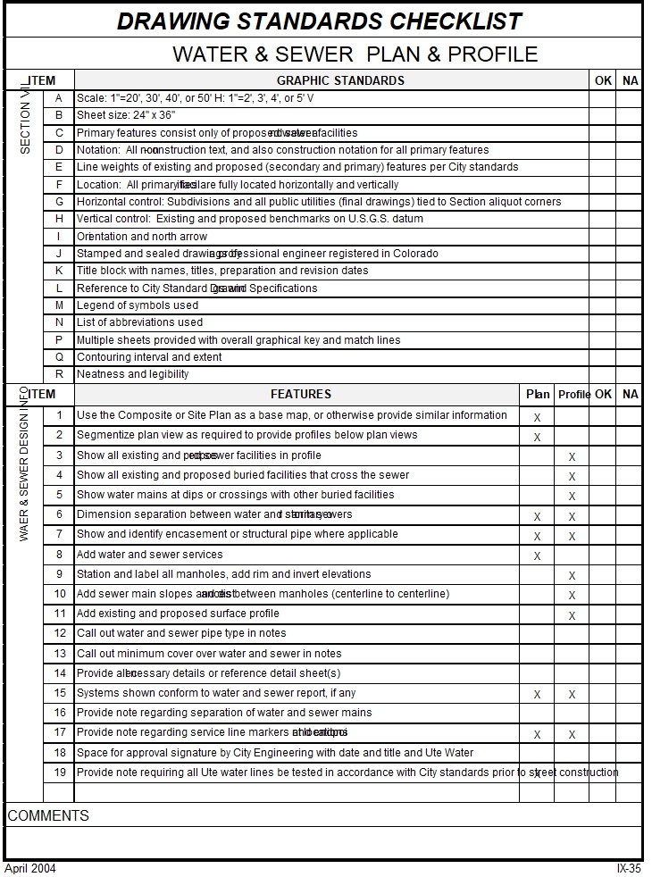
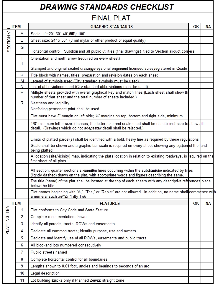
VIII. GRAPHIC STANDARDS
All drawings, maps, exhibits and plans shall conform to these standards.
A. SCALE Minimum and maximum scale permitted for each type of drawing is indicated in the description of the specific drawing. A bar scale shall be provided on each sheet having a plan view.
B. SIZE All drawings, exhibits, maps and plans shall be at least 11"x17" and not larger than 30"x42". All construction and as-built drawings and plats shall be 24"x36".
For 24"x36" drawings, bordering is required as follows: a minimum of 2 inches on the left side; and a minimum of 1/2 inch on all other sides, the maximum drawing area inside the border shall be 20" by 33½" to allow for one-half size reduction.
C. PRIMARY AND SECONDARY PROPOSED FEATURES Drawing checklists identify which proposed features are primary. All other proposed features are secondary and shall be drawn according to these regulations.
D. NOTATION Street names, lot numbers, utility types and sizes (such as 8" SAN for an 8 inch sanitary sewer line), contour elevations and other descriptive notations shall appear on all plans for all Facilities shown. Construction notation, such as notes that identify length, width, thickness, quantity, to construct or install, specifications or standards, removals, replacements, etc., shall be provided as applicable only for the primary features on a drawing.
E. LINE WEIGHT AND TYPE Acceptable pen sizes and line types for various features and text are presented on pages VIII-5 through VIII-10. Line weight and type for drawing existing features must contrast with that used for proposed features, such as using dashed/solid or light solid/dark solid combinations.
F. LOCATION Existing and proposed Facilities shall be shown graphically as close to the known or proposed location as possible, however, unless indicated otherwise, dimensions or other data locating a feature(s) is not required. Primary features on final construction drawings and existing Facilities to which proposed Facilities tie-in shall be fully described, horizontally and vertically, by station and offset, bearings and distances, dimensions and curve data, coordinates and elevations.
G. HORIZONTAL CONTROL Survey control for subdivision improvement drawings and plats must be tied to Section (aliquot) corners.
H. VERTICAL CONTROL One bench mark shall be given for all drawings with grades. If Facilities are proposed, then a permanent bench mark must be referenced with the elevation based on United States Geological Survey (USGS) datum or other approved datum obtained from local governmental agencies or sources. If the existing benchmark is far enough removed from the site that it reasonably cannot be shown on the plan, then the description of the benchmark location shall not only include aliquot corner description, but street reference. All proposed bench marks must be shown.
I. ORIENTATION All plan view drawings shall have a properly oriented North arrow. North shall be at the top or side of the drawing, however, in the case of sewer lines, pipes may be drawn to slope down to the left side of the drawing.
J. SEALED DRAWINGS All construction drawings and plats that are submitted for approval must be signed, sealed and dated by a Colorado registered professional engineer or professional land surveyor.
K. TITLE BLOCK Each drawing shall have a title block which provides the project name, drawing title and the name, address and telephone number of the author of the plan. A preparation date shall be provided and each re-submittal(s) shall have a revision date(s).
L. STANDARD DRAWINGS AND SPECIFICATIONS A note shall be provided on each construction drawing that requires Facilities to be constructed in accordance with all applicable specifications and standard details.
M. LEGEND OF SYMBOLS All symbols must be identified in a legend provided on the drawing or in the drawing set, both for proposed and existing Facilities. City drafting symbols shall be used (see pages VIII-5 through 10). A disk with City symbols is available from Community Development.
N. ABBREVIATIONS All abbreviations must be identified in a legend provided on the drawing or in the drawing set. City drafting abbreviations shall be used (see page VIII-4).
O. AS-BUILT DRAWINGS The words “As-built” or “Record Drawing” or “As Constructed” shall appear in 10 point bold lettering on each drawing that is represented by the Developer as an as-built. Design information which does not match as-built conditions shall not be erased, but shall be crossed out with a fine line which does not obscure readability. The correct information shall be provided immediately beside the design information and initialed by the person making the change. “As-built” drawings must consist of construction drawing prints with as-built information. All final as-built information and conditions must be submitted to the City on a disk suitable for use with a personal computer in a format compatible with DFX and DWG files. (See page V-2 for submittal format.)
As-built information must be neat and legible. Information which cannot be easily read will be rejected and the Applicant assessed a review fee and/or required to redraw and resubmit the as-built drawings.
P. MULTIPLE SHEETS Two or more sheets may be required for certain drawings in order to allow the profile to be on the same sheet as the plan. Each sheet shall have a reduced scale drawing of the entire site as a key, with match lines and sheet identification provided thereon.
Q. CONTOURS
1. Interval Contour interval shall be consistent throughout a drawing and conform to the following:
a. 1 foot for grades generally between 0 and 2%;
b. 2 foot for grades generally between 2% and 5%; and
c. 5 foot for grades generally in excess of 5%.
2. Extent Contours shall be shown beyond property or watershed limits in order to define gradients at the property boundaries. Proposed and finished contours shall be shown for road, detention/retention basin, drainage channel and swales, embankment and lot grading.
R. NEATNESS AND LEGIBILITY All drawings must be neat, legible and of such size that detail is not obscured or readability of text is not impaired. The City may reject any/all nonconforming drawings. When a drawing is rejected the Applicant may be assessed a review fee and/or required to redraw and resubmit the drawings.
City Standard Drafting Abbreviations
City Standard Drafting Symbols
City Standard Drafting Symbols
City Standard Drafting Symbols
City Standard Drafting Symbols
City Standard Drafting Symbols
DRAWING STANDARDS CHECKLIST |
AS-BUILT DRAINAGE |
ITEM |
GRAPHIC STANDARDS |
OK |
NA |
SECTION VIII |
J |
Stamped and sealed drawings by a professional engineer registered in Colorado |
|
|
O |
As-built drawings |
|
| |
R |
Neatness and legibility |
|
| |
|
|
|
| |
|
|
|
| |
|
|
|
| |
|
|
|
| |
|
|
|
| |
|
|
|
| |
|
|
|
| |
|
|
|
| |
|
|
|
| |
|
|
|
| |
|
|
|
|
ITEM |
FEATURES |
OK |
NA |
ADDITIONAL INFO |
1 |
Use the Storm Drainage Plan and Profile as a base drawing |
|
|
2 |
All vertical, horizontal, and other design information required for primary features in the Storm Drainage Plan and Profile must have corresponding as-built information provided, including elevations, station and offset, pipe and culvert slopes and distances, basin structures, etc. |
|
| |
3 |
As-built information for all significant changes from the approved design plans |
|
| |
4 |
Pipe and culvert type |
|
| |
5 |
Space for approval signature by City Engineering with date and title. |
|
| |
|
|
|
| |
|
|
|
| |
|
|
|
| |
|
|
|
| |
|
|
|
| |
|
|
|
| |
|
|
|
| |
|
|
|
| |
|
|
|
| |
|
|
|
|
COMMENTS |
1. As-built sketches and drawings must contain the same information. Submittal format is different. See Section VIII. |
April 2004 IX-3
DRAWING STANDARDS CHECKLIST |
AS-BUILT GRADING |
ITEM |
GRAPHIC STANDARDS |
OK |
NA |
SECTION VIII |
J |
Stamped and sealed drawings by a professional engineer registered in Colorado |
|
|
O |
As-built drawings |
|
| |
R |
Neatness and legibility |
|
| |
|
|
|
| |
|
|
|
| |
|
|
|
| |
|
|
|
| |
|
|
|
| |
|
|
|
| |
|
|
|
| |
|
|
|
| |
|
|
|
| |
|
|
|
| |
|
|
|
|
ITEM |
FEATURES |
OK |
NA |
ADDITIONAL INFO |
1 |
Use the Grading and Drainage Plan or Grading and Stormwater Management Plan as a base drawing |
|
|
2 |
Provide as-built pad elevations for all lots that are in or are adjacent to the 100-year floodplain |
|
| |
3 |
Detention/retention basin as-built contours (except for where on pavement, then use as-built grading). |
|
| |
4 |
Volume verification of detention/retention basin and outlet works |
|
| |
5 |
Drainage channel and swale as-built information |
|
| |
6 |
Space for approval signature by City Engineering with date and title |
|
| |
|
|
|
| |
|
|
|
| |
|
|
|
| |
|
|
|
| |
|
|
|
| |
|
|
|
| |
|
|
|
| |
|
|
|
| |
|
|
|
| |
|
|
|
| |
|
|
|
| |
|
|
|
| |
|
|
|
|
COMMENTS |
1. As-built sketches and drawings must contain the same information. See Section VIII for submittal format. 2. Detention/retention basin shall be surveyed to the extent necessary that a PE can verify the volume. The volume must be at least as large as the volume required in the drainage report. Volumes shall be calculated allowing for landscaping. The outlet works shall be surveyed and elevations and orifice/weir measurements shown on as-builts to the 0.01’ accuracy. |
April 2004 IX-4
DRAWING STANDARDS CHECKLIST |
AS-BUILT IRRIGATION |
ITEM |
GRAPHIC STANDARDS |
OK |
NA |
SECTION VIII |
J |
Stamped and sealed drawings by a professional engineer registered in Colorado |
|
|
O |
As-built drawings |
|
| |
R |
Neatness and legibility |
|
| |
|
|
|
| |
|
|
|
| |
|
|
|
| |
|
|
|
| |
|
|
|
| |
|
|
|
| |
|
|
|
| |
|
|
|
| |
|
|
|
| |
|
|
|
| |
|
|
|
|
ITEM |
FEATURES |
OK |
NA |
ADDITIONAL INFO
|
1 |
Use the Irrigation Plan and Profile as a base drawing |
|
|
2 |
All vertical, horizontal, and other design information required for primary features on the Irrigation Plan and Profile must have corresponding as-built information provided |
|
| |
3 |
As-built information for all significant changes from the approved design plans |
|
| |
4 |
Pipe and culvert type |
|
| |
5 |
Space for approval signature by City Engineering with date and title |
|
| |
|
|
|
| |
|
|
|
| |
|
|
|
| |
|
|
|
| |
|
|
|
| |
|
|
|
| |
|
|
|
| |
|
|
|
| |
|
|
|
| |
|
|
|
| |
|
|
|
| |
|
|
|
| |
|
|
|
| |
|
|
|
| |
|
|
|
|
COMMENTS |
1. As-built sketches and drawings must contain the same information. Submittal format is different. See Section VIII. |
April 2004 IX-5
DRAWING STANDARDS CHECKLIST |
AS-BUILT ROADWAY |
ITEM |
GRAPHIC STANDARDS |
OK |
NA |
SECTION VIII |
J |
Stamped and sealed drawings by a professional engineer registered in Colorado |
|
|
O |
As-built drawings |
|
| |
R |
Neatness and legibility |
|
| |
|
|
|
| |
|
|
|
| |
|
|
|
| |
|
|
|
| |
|
|
|
| |
|
|
|
| |
|
|
|
| |
|
|
|
| |
|
|
|
| |
|
|
|
| |
|
|
|
|
ITEM |
FEATURES |
OK |
NA |
ADDITIONAL INFO |
1 |
Use the Roadway Plan and Profile as a base drawing |
|
|
2 |
All vertical, horizontal, and other design information required for primary features on the Roadway Plan and Profile must have corresponding as-built information provided, including pavement width, curb/gutter/sidewalk width and type, base course, and pavement thickness, geosynthetics, sub-grade stabilization, elevations horizontal control, signalization, etc. |
|
| |
3 |
As-built information for all significant changes from the approved design plans |
|
| |
4 |
Space for approval signature by City Engineering with date and title |
|
| |
5 |
Provide tabulation of street length of new construction |
|
| |
6 | Provide elevations for all PC’s, PT’s, ECR’s, angle points, grade breaks, and all locations where elevations were shown on the design drawing. |
|
| |
|
|
|
| |
|
|
|
| |
|
|
|
| |
|
|
|
| |
|
|
|
| |
|
|
|
| |
|
|
|
| |
|
|
|
| |
|
|
|
|
COMMENTS |
1. As-built sketches and drawings must contain the same information. Submittal format is different. See Section VIII-2. |
April 2004 IX-6
DRAWING STANDARDS CHECKLIST |
AS-BUILT WATER & SEWER |
ITEM |
GRAPHIC STANDARDS |
OK |
NA |
SECTION VIII |
J |
Stamped and sealed drawings by a professional engineer registered in Colorado |
|
|
O |
As-built drawings |
|
| |
R |
Neatness and legibility |
|
| |
|
|
|
| |
|
|
|
| |
|
|
|
| |
|
|
|
| |
|
|
|
| |
|
|
|
| |
|
|
|
| |
|
|
|
| |
|
|
|
| |
|
|
|
| |
|
|
|
|
ITEM |
FEATURES |
OK |
NA |
ADDITIONAL INFO
|
1 |
Use the Water and Sewer Plan and Profile as a base drawing |
|
|
2 |
All vertical, horizontal, and other design information required for primary features on the water and Sewer Plan and Profile must have corresponding as-built information provided, including elevations, station and offset etc. for manholes, cleanouts, valves, vaults, bends, tees, crosses, fire hydrants, and other appurtenances |
|
| |
3 |
Ends of services (subdivisions only) must be tied to lot corners or be located by station and offset. The top of the pipe or invert elevation shall be shown for sanitary services. |
|
| |
4 |
As-built information for all significant changes from the approved design plans |
|
| |
5 |
Pipe type and type of pipe connections (MJ, SJ, FL, etc) |
|
| |
6 |
Space for approval signature by City Engineering with date and title |
|
| |
7 |
Tabulation of each utility – size and length (of new construction) |
|
| |
|
|
|
| |
|
|
|
| |
|
|
|
| |
|
|
|
| |
|
|
|
| |
|
|
|
| |
|
|
|
| |
|
|
|
| |
|
|
|
| |
|
|
|
|
COMMENTS |
1. As-built sketches and drawings must contain the same information. Submittal format is different. See Section VIII |
April 2004
IX-7
DRAWING STANDARDS CHECKLIST |
COMPOSITE PLAN |
ITEM |
GRAPHIC STANDARDS |
OK |
NA |
SECTION VIII |
A |
Scale: 1"=20', 30', 40', or 50' H: 1"=2', 3', 4', or 5' V |
|
|
B |
Sheet size: 24" x 36" |
|
| |
C |
There are no primary features on this drawing |
|
| |
D |
Notation: All non-construction text |
|
| |
E |
Line weights of existing and proposed (secondary and primary) features per City standards |
|
| |
G |
Horizontal control: Subdivisions tied to Section aliquot corners |
|
| |
H |
Vertical control: Benchmarks on U.S.G.S. datum if public facilities other than SW are proposed |
|
| |
I |
Orientation and north arrow |
|
| |
K |
Title block with names, titles, preparation and revision dates |
|
| |
M |
Legend of symbols used |
|
| |
N |
List of abbreviations used |
|
| |
P |
Multiple sheets provided with overall graphical key and match lines |
|
| |
Q |
Contouring interval and extent |
|
| |
R |
Neatness and legibility |
|
|
ITEM |
FEATURES |
OK |
NA |
REVISIONS
|
1 |
Use the Preliminary Plan as a base drawing, or provide the same information, except the approximate dimensions (item 18) |
|
|
2 |
Remove approximately dimensions (item 18 on the Preliminary Plan checklist) |
|
| |
3 |
Make revisions per Preliminary Plan review agency comments which were to be addressed in the final submittal process |
|
| |
4 |
Make desired developer initiated minor changes |
|
| |
5 |
Make refinements associated with a more detailed design |
|
| |
6 |
Show only proposed and not existing 100-year floodplains |
|
| |
7 |
Show proposed power, telephone, gas, cable TV, water, sewer, storm sewer and other utilities (unless shown on a separate plan) |
|
| |
|
|
|
| |
|
|
|
| |
|
|
|
| |
|
|
|
| |
|
|
|
| |
|
|
|
| |
|
|
|
| |
|
|
|
|
COMMENTS |
|
April 2004 IX-8

2004-06-02T11:10:00
[MSOffice1]
Who is the City liaison?
2004-06-02T11:11:00
[CoGJ2]
City of Grand Junction
???
2004-06-02T11:11:00
[CoGJ3]
City of Grand Junction
???
2004-06-02T11:14:00
[MSOffice4]
What does this mean? Obtain jurisdiction?
2004-06-02T11:14:00
[MSOffice5]
If what is proposed?